navbar
Feast Menu
| Detailed Schedule
| Deed of Arms
| Directions and Map
| Hotels nearby
| Gate Shift Assignments
Home
| SCA Inc.
| Bryn Gwlad
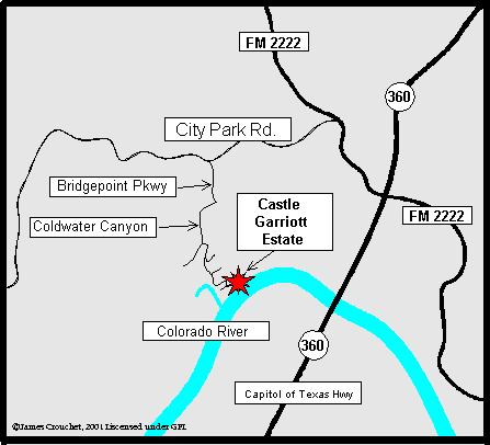
Detailed Directions to Castle Garriott
Coming into Austin, TX from the NORTH on I-35:
- Take the RM 1325 exit (exit 250) and turn right onto RM 1325 (headed southwest).
- After about 2.5 miles, the road will fork. Take the left fork onto Loop
1 (Mo Pac).
- After about another 2.5 miles, take the Capitol of TX Hwy exit (Capitol
of Texas Hwy is also called RM 360). Turn right onto RM 360/Capitol of Texas
Hwy.
- Stay on RM 360 for 4 miles. Take the RM 2222/Bull Creek Rd. exit to the
right.
- Follow the "From RM 360 & RM 2222" directions, below.
Coming into Austin, TX from the NORTH on HWY 183:
- Exit from HWY 183 onto RM 360 (also called Capital of Texas Hwy) headed
south.
- Take the RM 2222/Bull Creek Rd. exit to the right.
- Follow the "From RM 360 & RM 2222" directions, below.
Coming into Austin, TX from the SOUTH on I-35:
- Take the Ben White Blvd./HWY 290/HWY 71 exit (exit 229) and turn left under
I-35 onto Ben White Blvd. (west bound). Note that the area around exit 229
is under construction, so the exit sign may not have the number posted.
- When the road forks (about 2.7 miles), bear right. Signs should indicate
that fork goes to RM 360 (also called Capital of Texas Hwy).
- Stay on RM 360 (headed north) until after you cross the large suspension
bridge over the river (about 9.5 miles).
- Take the RM 2222/Bull Creek Rd. exit and turn left under RM 360 onto RM
2222 (headed west).
- Follow the "From RM 360 & RM 2222" directions, below.
Directions continued:
From RM 360 (also called Capital of Texas
Hwy)and RM 2222 (also called Bull Creek Road)
- Go West on RM 2222 about 0.4 miles to the first stop light at City Park
Rd.
- Turn left onto City Park Road and go about 0.9 mile (up the steep hill)
to Bridgepoint Pkwy.
- Turn left onto Bridgepoint Pkwy and go until it ends (about 0.1 miles).
- Turn right onto Coldwater Canyon drive. Follow this road around, past the
barricade to the cul-de-sac (about 0.3 miles).
- At the end of the cul-de-sac is a silver gate and a dirt road. Enter slowly.
- Follow the dirt road straight back, (you will pass a construction site).
The equestrian camping is in this area. Continue to the site, go through the
small cliffs and down the hill. Its a STEEP HILL so drive slowly.
- You will see us at the bottom of the hill, just follow the dirt road around
and look for the Gate Pavilion.
Map not to any known scale.
Map not guaranteed.
Follow written directions.
The site is the same one we have
used for Baronial Championships and
for Queen's Champion a few years ago. |
 |
The Barony of Bryn Gwlad's Event Website, a publication of the Society for Creative Anachronism, Incorporated (SCA, Inc.) is not a corporate publication of the SCA, Inc., and does not delineate nor set SCA policies. This site is strictly for delivering information on what is happening within the barony, and to give aid to anyone who would like to join the SCA.
This page created and maintained by HE Claire Shayhan, Virtual Scribe for Bryn Gwlad
mka: Elizabeth Crouchet, Web DesignerĀĀemail: ecrouchet@austin.rr.com
Homepage URL:http://www.swordworks.org/investiture
Copyright © 2003. Elizabeth Crouchet ĀRevised: April 25, 2003